Hello everyone,
while looking at the “data needs” section of the HQ quality model, I read that “the LULC raster should include the area of interest, as well as a buffer of the width of the greatest maximum threat distance”.
I’m not sure about the meaning of this buffer. Should I create one around the boundaries of the area of interest? Or should I extend the boundaries of the LULC beyond the borders of the area of interest (for example, if I considered an island should I have a LULC surrounded by the sea)?
Thank you so much for your help,
Marco
Hi @marco.guzzetti,
Basically this is saying that your threat rasters and area of interest should not be against the edges of the LULC because the model will want to decay that threat over a given distance and could cause some not intuitive edge effects. So in order to see the full effects of a given threat, that threat needs room to work.
Does that make sense?
Doug
Hi @dcdenu4
thank you for your reply. It makes sense theoretically but not practically. In other words, I’m not sure what should I do in QGIS. Should I create a buffer around the boundaries of my LULC? Which value should this buffer have?
Thank you so much, it’s the first time that I do something like that.
Best,
Marco
Hi @marco.guzzetti,
No worries. Now that I’ve thought about it more I believe that as long as your threat rasters are all within the boundaries of your LULC you should not have to do any kind of buffering. This phrasing in the Users’ Guide could be an artifact of how the model used to run where I think the intersection of LULC and threat rasters were taken. Now, in InVEST 3.8, everything is trimmed to the Union of all of those raster inputs. I’m going to tag @jdouglass to make sure I have this right.
Could you make sure that you are running the latest version of InVEST? InVEST 3.8
Best,
Doug
Hi @dcdenu4
Thank you for your reply (again). I’m using InVEST 3.7.0, do you suggest to remove it and to install the latest version?
Marco
@marco.guzzetti, yes, we definitely suggest upgrading to InVEST 3.8.0! There are a variety of fixes to the Habitat Quality model, specifically, in 3.8.0. @dcdenu4 is also right about how your LULC and threats should all overlap: just make sure that the distance between values of 1 in your threat layers is at least MAX_DIST from the edge of your LULC.
@dcdenu4, I’ll just add a little nuance to how threats are handled in 3.8.0, which is that the sizes of every raster are now adjusted to match that of the LULC. If a threat is smaller than the LULC, it’s expanded to match the LULC and the new pixels are filled with nodata. If a threat raster is larger than the LULC, it’s cropped to match the size of the LULC.
Thank you @jdouglass!
To paraphrase what you are saying, I should not build a buffer that goes beyond the area of interest if I understand correctly. However, let’s say that I have an urban area just at the border of my LULC and that I build a buffer around it. In that case, parts of the buffer will be beyond the LULC. So I wonder if the latest version of InVEST allows to overcome this issue.
Again, thank you both.
Marco
You should include a buffer around your area of interest. The point of this is to make sure that any effects of threats near the edge of your LULC are properly accounted for. You can safely ignore this buffering only if your threats are at least MAX_DIST away from the edge of your non-nodata LULC pixel values.
The software will run either way, it’s just that you usually want to be sure that the model is accounting for the effect of threats within your buffer radius 
Thanks for the input and clarity @jdouglass!
Let us know if this all makes sense Marco. If you do have edge threat cases, are you able to grab a wider boundary for the LULC rasters from an original datasource?
Doug
Dear @dcdenu4
I think that makes sense. I created a buffer around my LULC (in black, see picture below), and now I should consider which land use classes are my “threats”. In other words, I should have as many maps as threats. Each of these maps should have: the buffer around the whole area (the one here in black) + a buffer around the pixels I’m considering.
Does it make sense? Is it the right approach?
Thank you,
Marco
Hey Marco,
I would focus on getting the threat rasters created, where pixel values of 1 are considered a threat and 0 are considered not a threat. The easiest approach to creating these from the LULC might be to use the QGIS raster calculator tool.
As for buffering, perhaps the term buffer has been misleading. It might make more sense to think of it as stopping your threats short of the LULC edge by the greatest Max Distance of your threats. Ultimately, if your threats run up against the edge of the LULC and beyond (in the real world) you are not getting a fair representation of how those habitat are actually affected.
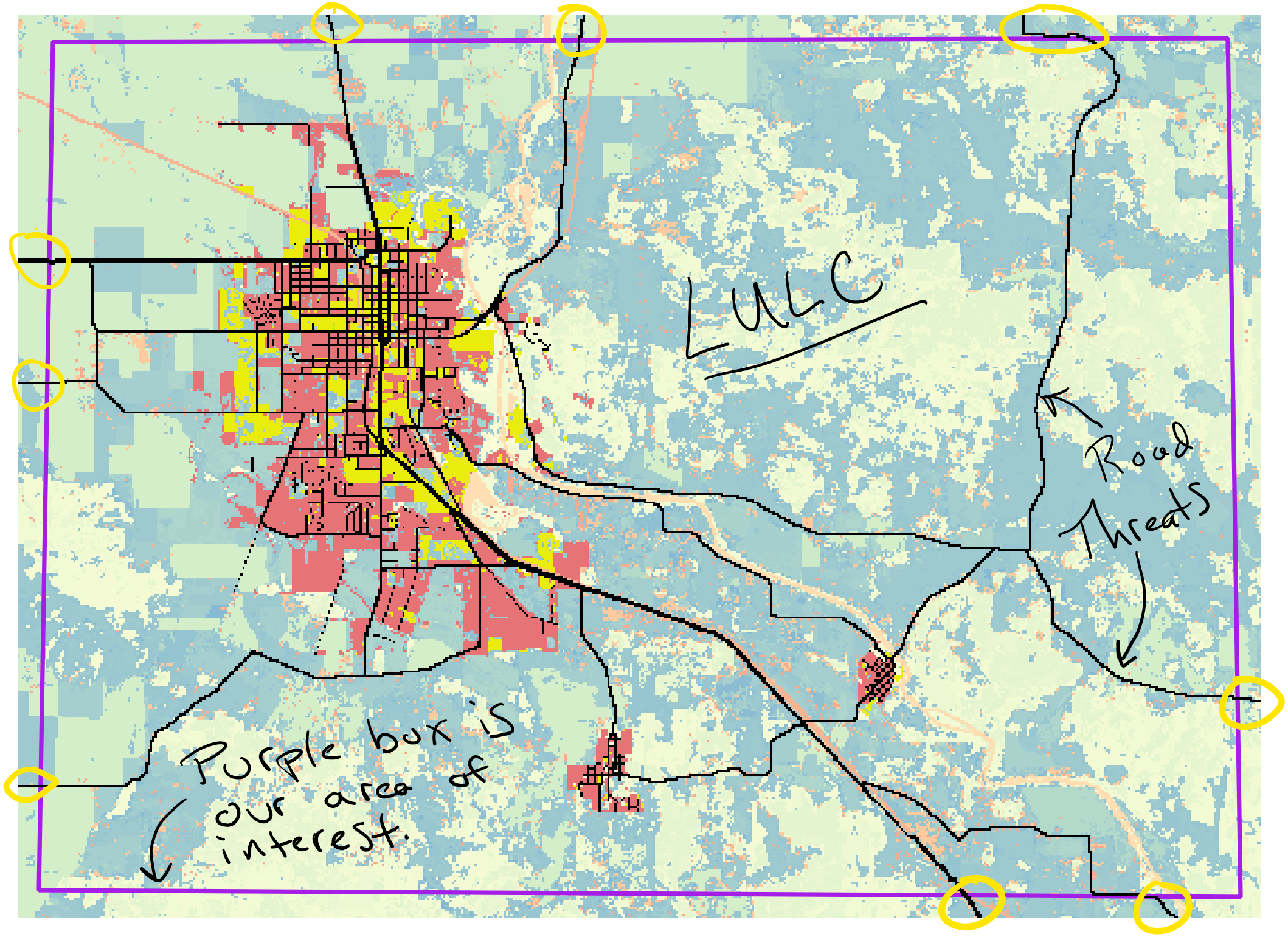
I have annotated the attached image to help demonstrate this. Here we have a LULC map (a cropping from the habitat quality sample data) with two rasters overlaid: 1) Roads as threats in black and 2) Urban as threats in yellow. Note that the road threats stop short of the edge of the LULC by 3km (the Max Distance of Road Threats), this is what we mean by buffering. In this instance your Area of Interest is the to the edge of the LULC. We can confidently say that given the threat layers all our LULC and habitats have been properly affected by the threats.
Similarly, as seen in the 2nd attached image, if we let our threats run to the edge of our LULC we need to understand that our Area of Interest will be the Max Distance of our edge threats from the edge of the LULC, represented by the purple box. Inside this box, we know that LULC habitat have all been properly affected by the given threats.
Sorry for the confusion and our struggle to make this as clear as possible. I’m going to add @jdouglass again, just make sure I am getting this correctly
Doug
Yep! @dcdenu4’s econd image here is what your inputs should look like.
In the Data Needs section of the HQ User’s Guide, it notes that:
The LULC raster should include the area of interest, as well as a buffer of the width of the greatest maximum threat distance. Otherwise, locations near the edge of the area of interest may have inflated habitat quality scores, because threats outside the area of interested are not properly accounted for.
So, either approach that @dcdenu4 mentioned will be correct, and which approach you choose will depend on the threats you’re choosing to model and whether they extend beyond the area of interest.
And if you use the second approach, be sure to only include what’s within the purple box in your analysis.
1 Like
Thank you both for these clarifications! Your help is super useful!
All the best,
Marco