natcap.rios-log-2023-01-13–19_06_43.txt (35.5 KB)
Hi @nishang1 -
The error is this:
Exception: The datasets’ intersection is empty (i.e., not all the datasets touch each other).
It’s saying that some of your spatial inputs do not actually overlap the others. This usually happens when your spatial inputs do not all have exactly the same projected coordinate system. So look at the coordinate systems for all of your spatial inputs, and reproject any that do not match the projected coordinate system that you want to use for your study.
You can also find more information about this error by searching this forum, it has been discussed before.
~ Stacie
Hi,@swolny .Sorry to bother you again.At your prompt ,I ran it successfully this afternoon.However, the result is like this .I don’t know if it is a setup error or a problem with my data.
Hi @nishang1 -
It’s good to hear that you’re making progress. Can you post the log file from the successful run of RIOS? I wonder if there’s anything in there that would explain why no activities are being mapped. Also, have you checked the spatial results? It might happen that activities are being mapped, but for some reason the HTML report isn’t being generated correctly.
~ Stacie
Hi@swolny ,I am glad you can guide me again.Here’s my log file.My space results are like this.Since I am using this software for the first time,I don’t know if this result is correct.
natcap.rios-log-2023-01-14–15_26_13.txt (292.0 KB)
Hi @nishang1 -
The values in the output layers are definitely not correct, there’s probably no data in them.
While I really can’t spend a lot of time helping with software that we no longer officially support, I would like to help you get a successful run. To do this, I’ll need to try to run RIOS with your data. Please zip up the following things and send them to swolny@stanford.edu:
1/ All of the spatial data and CSV tables that you’re entering into RIOS.
2/ In the RIOS user interface, select File → Save parameters, then click Save. Send me the “rios_parameters.json” file that is created. This is important so I have all of the parameter information (like budgets) that you’re entering into RIOS manually.
Hopefully I’ll be able to replicate your results this way.
~ Stacie
@swolny Thank you very much for helping me.I think without your help,I might have to give up my research.This is the spatial data and related biophysical data that you asked me to send you.
[Uploading: spatial data.zip…]
Hi @nishang1 -
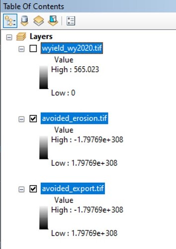
Thank you for sending your data. The first thing I see is that two of the layers that you are using for the “Other” Factor don’t seem to have data when I look at them in a GIS:
So I wouldn’t be surprised if these were causing the empty results you’re getting.
I’m running your data now, and since it took several hours for you, I expect it to take a while for me to be able to really verify that these are the problem. But I advise trying to run RIOS without the Other factor (so run it with only N, P and baseflow) and see if the results look any better.
~ Stacie
Hi,@swolny.Thank you for your help, I have successfully run the software with the correct results. However, when I tried to run Portfolio Translator, I didn’t know why I couldn’t load the workspace. Could you tell me, please.
Hi @nishang1 -
When you say that you can’t load the workspace are you referring to the entry in the user interface that says “Select RIOS workspace to build scenario from”? Or something else?
If the RIOS workspace is not being loaded, are you getting an error? If there’s an error, you can click on the red X and it will provide an error message that might help.
~ Stacie
Hi,@swolny ,Sorry to reply to you so late, mainly after my data is ready, click load rios workspace and it keeps showing memory error.
@nishang1 can you take a screenshot of the error and post it here? Thanks.
~ Stacie


